Sunday, 26 February 2017

Riding on the Camel Trail

Holly

We didn't see any camels today!
We hired bikes in Wadebridge on Friday.  It was a clear sunny day so it was a good day to go biking.  We went the Camel Trail to get to Padstow.  It was 5.5miles from Wadebridge to Padstow and I got worn out because I haven't been riding much lately.


When we got to Padstow there was Padstow harbour where I saw my first Cormorant. It was sitting on a buoy in the harbour.  We had a look around and then we went to a cafe and had a cream tea which was delicious.  Aidan's favourite is the Cornish clotted cream but I don't like the crumbly bits on the top.


During the ride we heard lots of birds singing but we couldn't see them all.  One of the birds we did see looked like a white heron.  I have to look up in my bird book to see what it is.
The bridge that we had to cross was a little wobbly but I hardly noticed it wobblng.  It was a old railway bridge because the camel trail is really an old railway line that has been ripped up and made for people to walk and ride on. We saw an old platform covered with grass and Aidan and I rode on it.  My favourite part was when we stopped to look at birds from inside a bird hide.

I would love to do it again if I could. It was a lovely day and I was so pleased when I saw the cormorant because I read about them in my Swallows and Amazon's books and I thought I would never see one.

Aidan

On Friday we hired bikes from a hire place called Bridge Bike Hire. The town we hired from was called Wadebridge. We rode from Wadebridge to Padstow which is over 5 miles. When we arrived in Padstow we locked up our bikes so we could go look at the town and harbour.  We found a restaurant that had cream teas so we had a very nice cream tea.

We saw two cormorants,  one was swimmimg the other was on buoy.   
Then we started walking back to the bikes.  Once we got back to the bikes we unlocked them and made our why back to Wadebridge. we rode past the hire place and kept on going through the town  towards Bodmin but we did not get all the way because there was road works going on so we turned around and made our way back,
 On the way holly and I rode up onto an old platform the platform was there because the camel trail used to be a railway.

We made it back to the hire place just before he was closing and after that we went back to the car  and Dad and Mum went to buy some food for dinner. 


Ancient stones in Cornwall

Today we saw some ancient monuments in Cornwall.

The first one we saw is called King Doniert's Stone.


The stone is part of a medieval cross and was carved in the 9th Century. There are beautiful patterns carved on the stones and one of them has an inscription with the name of a Cornish King. This is why it is called the Doniert Stone.  It is over 4 feet high

The other stone is called the 'Other Half Stone' and it is decorated with a carved plait.  


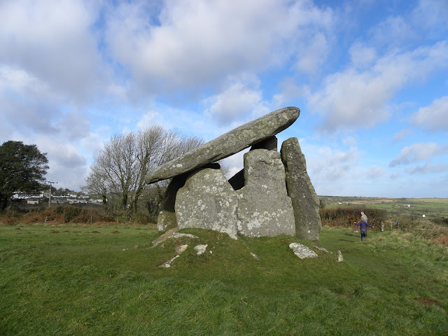
The next stone monument we saw is called Trethevy Quoit and it is an ancient burial chamber. It is also from the 9th Century so it might be more than 2500 years old.   It is made of 5 standing stones with a capstone on the top and is 2.7 metres high.


It would have been built to hold the remains of people who belonged to one of Cornwall's early farming communities.  The capstone on the top weighs about 20 tonnes.  The local people call Trethevy Quoit 'The Giant's House' because there is legend that says that giants hurled the stones together in a game of quoits.   When it was first built it would have been surrounded by a mound of stones called a cairn and only the capstone on the top would have been visible.  


The last place we visited was the Hurlers Stone Circles on Bodmin Moor.  The hurlers are near a town called Minions which is the highest town in Cornwall.  It was really, really windy when we got there.  
The trees on the moor grow like this because it is so windy there a lot of the time.


The Hurlers are 3 circles made of standing stones.  This is the only place in England where there are stone circles arranged in a line.  As well as the circles, there are 2 stones that stand on their own and they are called the Pipers. 

The legends says that the stones are men that were changed into stone because they played the game of hurling on a Sunday. The 2 stones called the pipers are men who played tunes on a Sunday so were turned to stone as well.

One circle has 15 stones but would have originally had 30. The middle circle has 14 stones and the last one has 9 original stones but most them have fallen down. All of the stones were hammered smooth.


We also saw the Cheesewring which is a pile of granite stones on the edge of a quarry.  They were formed naturally by the weather on the moor.  Because it was so windy and rainy we didn't go to the cheesewring, but Mum walked across the moor to have a look at it.  


Carnglaze Slate Caverns

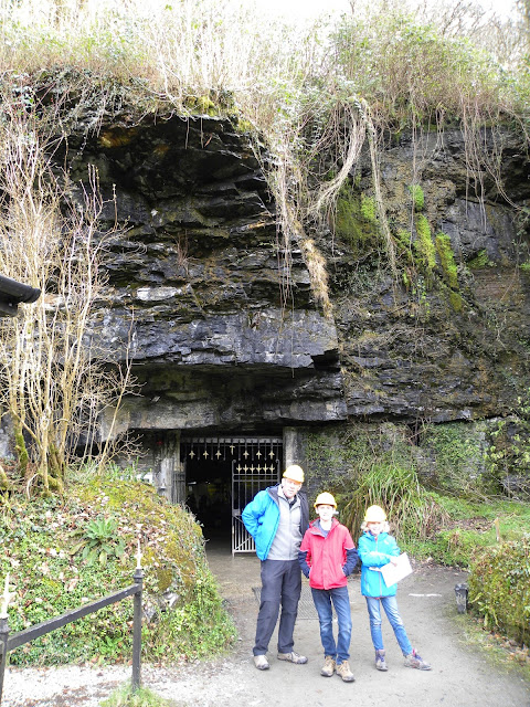
Today we visited the slate mine at Carnglaze.

 This is the only underground slate mine in Cornwall and has 3 large chambers.  The slate was mainly used for roofing.

In the 1700's miners wanted better quality slate so they started digging underground.  This also meant that they could work in all weathers. The slate mine was always about 10 degrees celcius which was a comfortable temperature all year round.

Instead of using ladders they used the rubble left from the mining to climb on and slowly dig the mine upwards.

The only light they had was candlelight.  The men worked in teams. There were 5 men in a team, 3 drillers, a splitter and a dresser.  One man would hold the drill bar and the others would hit it with sledgehammers. Doing this they could drill a hole about 1 foot deep in an hour.  One of the safety methods they used was that the man holding the drill bar would often be a young boy of about 14 years old and he would be related to the men with the hammer.  This was because the men with the hammer would be more careful with someone who was related to them.
These are the steps down into the chambers underground

The hole was packed with black powder which wasn't as dangerous as dynamite.  Each hole would blast about 1 metre cubed of rock.  This was done by lighting a safety fuse in the black powder which burnt at the rate of 1 foot a minute.  They lit the fuses at the end of the day as the men were leaving so the dust could settle before the next working day.
this is a pile of rubble that the miners would use to stand on to dig deeper into the ground

The next day the men would clear out the large blocks of slate and take then to the entrance of the cave where the splitter worked because he needed shelter and daylight. We saw a man demonstrating how to split slate when we visited the Llanberis slate museum in Wales.  He could split the slate into pieces only a few millimetres thick.  The other member of the team was the dresser and he had a knife called a zax so he could shape and trim the slate into the sizes they wanted.

The miners were paid by the piece and they were paid in tokens which they could only spend in the  mine shop. I think this system is horrid because if you got paid real money you could go to any shop and buy probably more than you could in the mine shop.

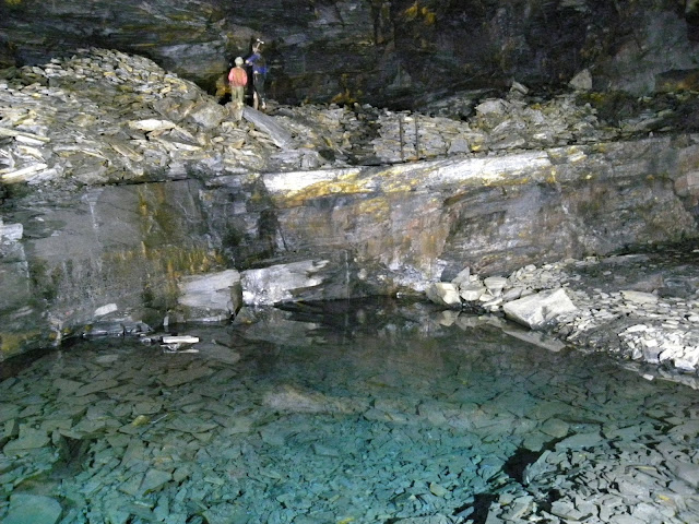
In the mine are 2 lakes.  One is called the baby pool and although the slate is waterproof water can still find ways through the gaps and cracks in between the rock to get into the mine.  The pool looks very shallow but it is actually 2 metres deep.  The water in the pool looks green but is actually isn't. The reason it looks this way is because there is a mineral in the rocks called mica which makes the water look this way.  This is why the sea in Cornwall always looks bluey green in the sun.  The water in the pool slowly runs underneath the mine floor and finally makes it way to the river below.


The other pool is called the Mother Pool and it is quite a lot larger.  It also looks shallow but is is 9.5m deep.


It was really interesting visiting the mine and learning about how they got the slate.  The pools were beautiful.


Friday, 17 February 2017

Port Isaac

Holly


Port Isaac is where the tv show Doc Martin is filmed and it is where we went today. To get there we had to o down windy lanes and they were very narrow.  If a car was coming the other way we had to pull over and sometimes one car has to go backwards to a where there is a gateway or somewhere wider.

We had to park the car outside the village because you can't drive cars in. When we got there we went to the beach in front of the harbour and the tide was in. The beach was small and rocky and I did some stone skimming.

There were lots of crab pots and fishing things near the harbour.


We went for a walk past the house where Doc Martin lives and we went along the cliff for a walk.


When we came back we went to have lunch at the Krab Pot and I had crab with bread and butter. It came in a crab shell and it was nice with lemon on it but it was a bit too crabby.  It was my first time having crab.

After lunch we went back to the beach and the tide had gone out a long way so that the fishing boat that had come in was nearly aground!


Aidan

The place we visited today was where Doc Martin is filmed and it is called Port Isaac.  The last season will be starting filming in a months time. Holly and I spent a bit of time on the beach skimming stones then I went with mum to look around some of the narrow lanes. Mum and Dad then had a coffee while we were on the beach. Then we  started to walk up a hill to were the house that was owned by Doc Martin in the tv show was, we then continued to walk up so we could walk up a cliff it was hard going up but alright going down.

When we got to the bottom we went to have some lunch at a cafĂ© called the Krab Pot. It was very nice food and there were 3 dogs in the cafe. After lunch Holly wanted to go back to the beach to skim some more stones so we did.  The tide was out so we could go farther out .the tide went out quite fast. we saw a fishing boat come in earlier so we could see the bottom of it.  Holly wanted to take her shoes off and go out to it but Mum said no because the water was cold. The people in the boat could not get the boat right up because it would get stuck in the sand so they had a row boat they went to shore in. We did not see them rowing. Port Isaac had a pottery shop but we did not find it.

Then we had our long walk back to the car because we did not have much time left we went for a bit of a drive to try and find a coastal walk for the dog at this sit we found a place not far from the port.   


Thursday, 16 February 2017

Boscastle 16 February 2017

Today was awesome because we got to look through some super strong binoculars and see a ship 19 miles away!

We went to Boscastle which is a village in Cornwall that has a harbour.  There were lots of slippery rocks to climb on and a beach that I went onto to skim some stones.  One of my rocks skimmed lots of times.

The harbour has 2 walls that were built in 1584 and a breakwater that was first built in 1820.  It is a hard harbour to get into for ships so a special boat called a hobbler would go out to tow them into the harbour and the ship had to be kept in the middle of channel by men pulling on ropes.


In the village there was a pottery shop and there was a man in their throwing pots. They decorate the pots with a tree patterns which made from a special juice they brew from tobacco.  It is called mochaware.  The patterns were very pretty.


There was a cliff that we climbed up to see if we could see the Boscastle blow hole but it wasn't blowing today.


On our way down the cliff Aidan & I went down to the beach. I found a small crab sheel with purple inside of it.  Next we climbed up another cliff where there was a coastguard station and the men in it were called John and Chris.  They let us all look through their awesome binoculars. You could see a French ship laying cables and it was 19 miles out to sea!  They also had a radar and a computer and we could see which ship it was on the computer..


I also saw an eagle up in the clouds and he was very pretty.  On the way back to the harbour we could see the fields which are called the stitches.  They look like they have been stitched up in rows.  The stitches are from medieval times when the fields were divided up with little banks so that different people could own different parts of the one field.
these are the stitches

I had an amazing day and saw lots of things. 


Tuesday, 14 February 2017

Ironbridge


Today we visited the village of Ironbridge to see the iron bridge.  The village is built on the bank of the River Severn in Shropshire and the village is named after the bridge that is built over the river.  The bridge was the first in the world to be built out of cast iron. 


We visited the information centre in the tollhouse at the end of the bridge and this is what we learnt about the bridge. 

In the 1750’s the only way to cross the river was by ferry boat.  There were 6 ferry’s crossing the river but the river was sometimes too shallow in summer and too fast in winter. 

A man called Thomas Farnolls Pritchard came up with the idea of building a bridge from cast iron.  He sent his designs to a man called 'Iron Mad' Wilkinson who was obsessed with iron and devoted his life to finding as many things to do with it as possible (he built the first cast iron boat, minted coins and had his own coffin and tombstone made from cast iron)

Along the river was an iron smelting factory and furnace at a village called Coalbrookdale.  When they discovered that iron could be smelted with coke instead of charcoal it made it cheaper to produce. 
A man called Abraham Darby who ran the company decided to make the bridge out of iron because it would be a good advertisement for his company.

In 1776 the Act of Parliament was passed authorising the Bridge and work began in November 1777.

The bridge uses 378 tons of iron and is made of 5 arches. Its height is over 16m from the water and the road along the top is over 7m wide.

To cross the bridge you had to pay a toll and the tollhouse is still standing at one end of the bridge. 
This is the tollhouse

this is a sign on the tollhouse saying what the toll to cross the bridge was


The bridge was very expensive to build.


In 1934 the bridge was closed to traffic and you can only cross it on foot.  It is now listed as an ancient monument.  In 1950 they stopped making people pay a toll to cross the bridge and it is now listed as an ancient monument.


This is the village of Ironbridge from the top of the bridge